SVETLANA PANASYUK
 Home Home
Resume
Publications
Medical Hyperspectral Imaging
Basics
Device
Diabetes
Wounds
Cancer
Shock
Optical Metrology
Defects
Medical
Automotive
Tissue Spectroscopy
Fluorescence
D-Reflectance
Device
Mantle Flow
Convection
Drift
Geoid
Compressibility
Inversion
Topography
Phases
Superplasticity
Hemisphere
GPS
Tien Shan
GPS
Sky Map
Errors
Remote Sensing
Vectors
Satellites
Image Processing
Deblurring
Registration
Recognition
Fun
Geosystems
Colormap
Chaos
Bubbles
Harmonics
Reference Earth Model
about
data
map_view
slice
isosurface
rms
correlation
vis5D
|
|
|
|
|
 Geoid is an equipotential surface. Geoid is an equipotential surface.
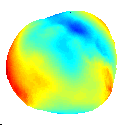 If our Earth would be a 100% water covered planet, its surface would look like a travel case: squashed from
above-to-below and from side-to-side.
If our Earth would be a 100% water covered planet, its surface would look like a travel case: squashed from
above-to-below and from side-to-side.
Actually, if you look at it from space you probably won't see the
side-to-side anomalies because they are relatively small compare to
the ellipsoidal one. But if you'd put on 'magic glasses' which enhance
the anomalies relative to the Earth radius, that's what you'd see from the space!
The North pole is up. The black vertical line cuts along Greenwich.
But, of course, when we say 'Geoid Anomaly' - we would rather imagine a steady picture:
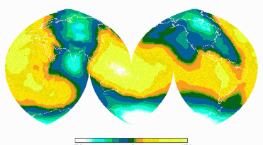
Here we took off the ellipticity (as due to the Earth rotation), and displayed the Geoid Anomalies using
interrupted Hammer-Aitoff projection with the continents sketched with white line on the background.
This topography of an equipotential surface is about +/- 100 meters, and it is a clear representation of the
lateral variations in the Earth density!
Those density contrasts drive the mantle flow: the lighter rocks flow up and the denser ones sink down,
very-very slowly.
Schematically I view it like this:
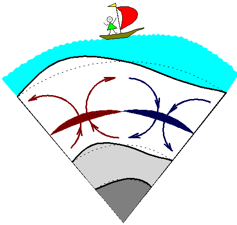 Imagine a slice through the Earth, as in picture on right. The dark gray is inner core: greatly
hot-pressed solid metallic ball. The light gray is outer core: hot but not as greatly pressed as the
inner core material - and therefore it's in a liquid state, giggling and convecting at high rates of several
km per year (some places reaching 10-20 km/year!! - it's like 2 meters in hour). Above is the mostly silicate
rock mantle (white layer in picture, although most abundant rock in upper 600-km of mantle looks like
light-green glass). The mantle creeps very slow (about couple centimeters per year) driven by the gravitationally
unstable blocks of rocks. Light-density, hotter rocks are colored reddish here and the heavier (cooler) chunks
are bluish.
Imagine a slice through the Earth, as in picture on right. The dark gray is inner core: greatly
hot-pressed solid metallic ball. The light gray is outer core: hot but not as greatly pressed as the
inner core material - and therefore it's in a liquid state, giggling and convecting at high rates of several
km per year (some places reaching 10-20 km/year!! - it's like 2 meters in hour). Above is the mostly silicate
rock mantle (white layer in picture, although most abundant rock in upper 600-km of mantle looks like
light-green glass). The mantle creeps very slow (about couple centimeters per year) driven by the gravitationally
unstable blocks of rocks. Light-density, hotter rocks are colored reddish here and the heavier (cooler) chunks
are bluish.
Since mantle is extremely viscous (on geological time scales), its flow causes topography at all outer boundaries
(surface, which is covered with the blue ocean, and the core-mantle boundary).
The deviations of density from the spherically symmetric distribution
cause an anomaly in the potential field of our planet. This anomaly
detects itself through the deflections of an ocean surface (which
merely coincides with the equipotential level). To determine how much
of this deflection is due to the primary-source (the density
contrasts in the mantle) and how much is due to the boundary deflection
(the secondary source), we have to know the rheology of the media
surrounding a mass anomaly. Should one know the exact density structure
and the viscosity of the Earth, one can repeat the very real mantle
motion and reconstruct the topography and geoid.
Here I illustrate how the equipotential surface reacts to the changes in the rheology of the media surrounding
a mass anomaly:
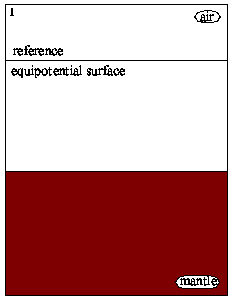
Let's consider 2D-Cartesian geometry, for simplicity. When no mass anomaly is present in the media
(mantle), the equipotential surface is flat (here it's called a reference equipotential surface and is shown by
black line)
 |
Now we add a heavy mass anomaly. In a rigid media (we do not allow any motion) it causes a 'cavity'
in the gravitational potential field, so it shows up as a bulge in the equipotential surface: positive geoid
anomaly (blue line)
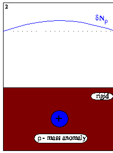 |
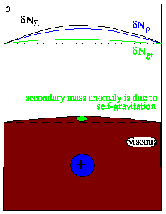
Holding the mass anomaly still, we allow the media to respond to the change in the gravitational
field: its free upper surface would be pulled up to equilibrate (to line up) with the equpotential level (effect
of self-gravitation). Thus created topography (I call it secondary mass anomaly) would re-adjust the potential
field (and geoid, green line).
 |
Now we let the mass anomaly to sink down. The viscous stresses of the generated flow pull the upper
boundary down creating another secondary mass anomaly (so called dynamic topography) which is, by the way, has
an opposite sign (lack of mass at the surface) and causes an opposite-sign (negative) anomaly of the geoid
(magenta line).
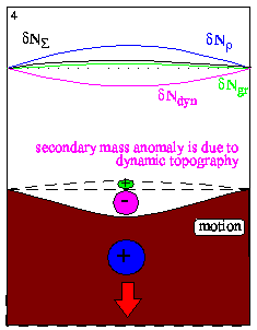 |
What we observe on the Earth surface is the total geoid anomaly (black solid line), which is the sum of all these
contributions from the primary density anomaly (blue), the dynamic topography (magenta), and the self-gravitation
(green). Although primary source can be inferred from numerous seismic tomography models, the two latter
contributions (which provide about same-amplitude compensating effect) depend on the rheology of our planet, and
therefore are much more ambiguous.
|
|