SVETLANA PANASYUK
Medical Hyperspectral Imaging
Optical Metrology
Tissue Spectroscopy
Mantle Flow
GPS
Remote Sensing
Image Processing
Fun
Reference Earth Model
|
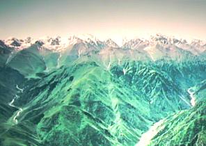 This photo picture was taken from a helicopter flying above and across Northern Tien Shan. The scar from a
centures ago earthquake with the open rupture is perfectly seen on the slope of the front mountain!
This photo picture was taken from a helicopter flying above and across Northern Tien Shan. The scar from a
centures ago earthquake with the open rupture is perfectly seen on the slope of the front mountain!
Short geological overview of the Tien-Shan area: The recent tectonics of the Tien Shan appears to be dominated by thrusting on roughly E-W striking faults and by folding of Cenozoic sediments, particularly along the ranges. The high level of historical and instrumental seismicity implies that crustal deformation in the Tien Shan is rapid. During the last hundred years, four great earthquakes with M~8.5 and five shocks with M~7 have occurred. Fault plane solutions and centroid depth determinations are compatible with shortening nearly perpendicular to the overall trends of the belt and consistent with the idea that Tien Shan overthrusts the Tarim to the south, and Kazakhstan and Dzungaria to the north. By summing inferred moments of four earthquakes with M>7.5 in the last 90 years, it was estimated that the present day shortening rate across the Tien Shan is about 13 mm/yr. However, the recent analysis of our GPS-network data implies the shortening rate for the Tien Shan of about 20 mm/yr! That suggests that the rate of mounting building in this region has accelerated several-fold since onset of collision (which was about 50 Millions of years ago!!). If we extrapolate this shortening rate backwards in time - the results are that most of the Tien Shan has been constructed during past 10 Millions of years ago! With such high level of seismicity and with rapid deformation, Tien Shan gives the opportunity to study pre-, post-seismic, and localized deformation of intracontinental tectonics. Tien Shan provides a laboratory to study intracontinental shortening without the influence of asymmetries, of kinematics and structure established at the time of the collision. The Tien Shan offers a good example of a second feature peculiar to intracontinental deformation. A major strike-slip fault, the Talaso-Fergana fault, truncates the western part of the region, cuts off the east-west trending blocks and the faults between them. Moreover, the Talaso-Fergana fault ends in the north-western part of Tien Shan. In oceanic regions, transform faults, along which slip is constant, abruptly truncate at spreading centers and subduction zones. In continental regions, however, strike-slip faults do not end rapidly, but seem to 'die out' by distributed, permanent deformation on one or both sides of the fault. The Talaso-Fergana fault is perhaps the world's premier example of such an intracontinental strike-slip fault. Slip seems to be rapid, possible 10 mm/yr. Yet, the fault passes from being a major structure to being absent in a distance of only 100 km. Bounding the fault on both sides are high ranges suggestive of rapid crustal shortening, but possibly reflecting rapid rotations about vertical axes. The geometry of deformation permits to determine the kinematics of deformation using GPS. |
 Tien Shan